The generic name tropical storm is applied to typhoons, cyclones and hurricanes. These storms form over tropical waters in the Atlantic, Pacific and Indian Oceans.
In order for a tropical storm to form several different factors must come together. The water must be over 28C (80F) and deep enough to provide the energy needed to power the storm. The depth required is unknown but the warmer the water the less the depth that is required as more energy is held in the water: the minimum depth required appears to be fifty metres.
The storm season is towards the end of summer and start of autumn when the ocean waters are warmest but the air is beginning to cool. For a storm to form the air over the sea must cool quickly allowing heat to be rapidly released into the air along with moisture. The moist air rises more quickly than it can be replaced from below, creating an area of low pressure. If the mid-troposphere is also moist (five kilometres above the earth) a column of warm moist air is formed. Air moves towards the area of low pressure to fill it.
A storm will not form even now unless certain other conditions are met. Some sort of surface or near surface disturbance is necessary to start the winds circling inwards to fill the area of low pressure, but there must be no winds crossing the area, which would disturb the initial formation by disturbing the vertical air convection necessary.
The centre of the storm needs to be more than five hundred kilometres (three hundred miles) from the equator. This allows the Corriolis effect to maintain the necessary low pressure at the centre of the storm, and determines the direction of spin of the winds. South of the equator the winds spin in a clockwise manner, and north in an anticlockwise manner. Until wind speeds in the system exceed thirty-nine miles per hour the system is known as a tropical depression, at higher speeds than this the depression is classed as a tropical storm.
As wind speeds pick up the category of the storm is upgraded, starting at force one and rising to five for speeds in excess of one hundred and seventy five miles per hour. The rising temperature of the air in the eye lowers the pressure in that area even more feeding the power of the storm further.
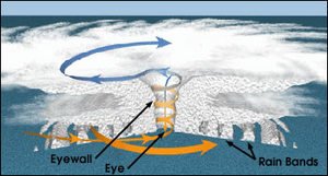
The centre of the storm can vary in size from thirty to one hundred kilometres across and is known as the eye. Inside the eye there are no clouds and little wind. The highest wind speeds are experienced in eye wall. Winds of over two hundred miles per hour were recorded in the eye wall of Hurricane Camille. A fully developed tropical storm has a clear eye area. Winds spiral up the eye wall throwing wind and moisture out at the top, leading to the classic satellite image we see.
As long as the storm continues to travel over the warm seas required to feed moisture and energy into the atmosphere the storm will continue to grow in size and force, this is known as the “heat engine. Larger hurricanes can release energy in the form of heat equivalent to an entire years energy production in the United States. Once the storm hits cooler water or land it will collapse, releasing all the stored moisture as rain. The storing of energy over water is the reason that storms crossing the Atlantic from the African coast will have more force than those forming in the Caribbean.
The El Nino effect is important in predicting the frequency of storms. During an El Nino event the eastern pacific warms up and storms become more frequent in that region and activity in the Caribbean decreases. Storms will still occur, just less frequently.
An understanding of how these storms form is the first step towards perhaps being able to prevent them.