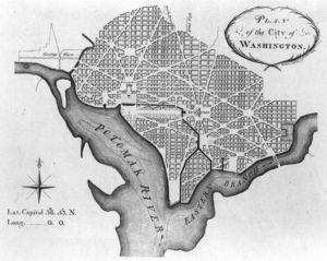
Washington, D.C. is the most confusing city in the United States of America. The Pierre L’Enfant city plan was developed out of visions of grandeur for a Capital City that was to emerge out of Maryland and Virginia swampland. The Baroque design predates automobile traffic and is an intimidating mix of narrow streets, one-ways, radials, circles, squares, and four distinct quadrants. Of course, this befuddling array is further exacerbated by the unique geography of the region.
The Potomac and Anacostia, two major tributaries of the Chesapeake Bay watershed bisect Washington, D.C. The area also rests upon the East Coast Fall Line, which juxtaposes the hilly Appalachian Piedmont with the Atlantic Coastal Plain. The natural barrier topography of the District promulgates confusion, bottlenecks, and a dearth of viable cross-town options at both rivers and Rock Creek Park.
Politically, the “expressway” network is almost non-existent due to years of “Not in My Backyard” backlash towards all proposals regarding inner-city freeway build out. Hence, principal routes start, stop, change directions, switch names, and disappear altogether at the Nation’s Capital. Improper signage adds to the mayhem, as several markers were placed at the beginnings of routes that have been long abandoned.
Although Washington, D.C. is a marvel for roadway enthusiasts and students of city planning, the Capital region is an unmitigated traffic nightmare for the majority of the population. Ironically, the vehicular mixing bowl and gridlock inside the Beltway have become quite synonymous with the machinations of our Federal Government.
This DC street guide and grid is designed to alleviate the madness, somewhat.
Please do not despair. Decades – long veterans of the Washington cityscape continue to be confounded and lost amidst this matrix. Let’s introduce the basic concepts:
Washington, D.C. Street Guide and Grid: U.S. Capitol and D.C. Quadrants
Fittingly, the United States Capitol is Ground Zero for the Washington, D.C. street grid.
The U.S. Capitol divides the District into four separate Northwest, Northeast, Southwest, and Southeast quadrants. Logically, North Capitol Street, South Capitol Street, East Capitol Street, and one plane dividing the National Mall west of the Capitol delineate these quadrants. These important thoroughfares converge at the U.S. Capitol from the cardinal directions.
Numbered streets run north and south; and lettered street run east to west – beginning at the U.S. Capitol. Lettered and numbered streets have been laid out in pairs and are differentiated per quadrant. For example, there are two separate, continuous 1st streets on both sides of the Capitol.
1st Street to the east of the U.S. Capitol will be Northeast or Southeast. 1st Street to the west will be identified as 1st Street NW or 1st Street SW. Specifically, 1st Street east of the U.S. Capitol and north of East Capitol Street is 1st Street NE. 1st Street NE headed south and running continuously past the Capitol across East Capitol Street becomes 1st Street SE.
63rd Street NE carries MD 704 traffic into Southern Avenue at Washington’s far eastern corner and 52nd Street NW marks a series of cul de sac – like enclaves near the Dalecarlia Reservoir bordering Montgomery County.
Got that?
Lettered streets follow a similar pattern. Again, Washington, D.C. features two parallel, continuous C Streets. C Street west of North Capitol Street and north of the National Mall is C Street NW. A and B streets are actually Madison and Jefferson drives (A Street) and Constitution and Independence avenues (B Street), which bound the National Mall.
The city also skips J, X, Y, and Z streets. The J was omitted to avoid being confused with I Street.
Further away from the Capitol, Washington, D.C. street names transition into two-syllable markers, alphabetically. Going north, these streets are Adams, Barry, Bryant, Channing, Douglas, and so on, and so forth. Northwest and Northeast are the larger sections and both require the alphabet to begin anew with three-syllable street names at Allison, Buchanan, and Crittenden; or Albemarle, Appleton, and Brandywine west of Rock Creek Park.
Northwest, the largest quadrant, requires a fourth and last alphabetical system for east-west streets. The final order is identified with forestry. Aspen, Butternut, Fern, Geranium, and Juniper streets intersect Georgia Avenue and 16th Street towards the Maryland border.
Washington, D.C. Street Guide and Grid: Addresses and Block Numbering
Addresses generally move in blocks of 100 from the U.S. Capitol.
All streets retain their appropriate suffix in relation to this landmark.
For example, the White House at 1600 Pennsylvania Avenue NW is situated at 16th Street and Pennsylvania Avenue. Obviously, this location is northwest of the U.S. Capitol, or north of the National Mall and West of North Capitol Street.
North-South streets follow a similar arrangement. Still, difficulty arises because the mind is not trained to think of lettered streets in terms of sequential numbers. 305 6th Street SW would represent the corner of 6th and C Streets southwest of the U.S. Capitol. “C” is indeed, the third letter of the alphabet.
Although some street signs do list the numerical addresses of the corresponding block – D.C. block signage is spotty at best and should even be ignored. Block numbering is a difficult pattern to follow outside of downtown due to the crushing amounts of meandering streets that go by letters and proper names, rather than numbers.
This is not Chicago, where 2400 W – 4000 N, is easily associated as Western and Irving Park.
Frankly, Washingtonians, motorists, and tourists venturing deep into the city proper, will fare better by memorizing the major through routes and wandering towards a general area, than attempting to pinpoint address coordinates per this confounding street grid.
Washington, D.C. Street Guide and Grid: Radials and Street Terminology
Ahh. The fun really begins!
Pierre L’Enfant integrated diagonal streets into his plan to provide sweeping views and vistas of this monumental city. Of course, the navigation of these radials is the primary factor behind the traffic circles, squares, and dubiously named streets that continue to frustrate many a Washingtonian.
Radial streets that converge downtown towards the National Mall effectively double as the District’s “expressway” network. Imagine the madness of shutting down all city wide Interstate traffic and forcing the flow onto signaled, surface streets. This is the essence of Washington, D.C.
L’Enfant’s hub and spoke pattern overlays the functional 90-degree street grid.
MacArthur Boulevard, Massachusetts Avenue, Connecticut Avenue, and Georgia Avenue are predominantly north-south thoroughfares that carry traffic from Montgomery County, Maryland into downtown via Northwest Washington, while New Hampshire Avenue, Rhode Island Avenue, New York Avenue, Pennsylvania Avenue, and Suitland Parkway traverse the District from Prince Georges County.
Tourists and out-of-towners will note that numbered U.S. routes and numerical shield signage vanish from D.C. streets, in favor of proper names. Obviously, Washington is a different municipality than the state of Maryland and MD 4 (Pennsylvania), 5 (Branch), 97 (Georgia), 185 (Connecticut), 210 (Indian Head Hwy. – S. Capitol), 214 (Central Ave. – E. Capitol), 320 (Piney Branch), 355 (Wisconsin), and 650 (New Hampshire) reassurance terminologies will all terminate at the border. However, the tracing of U.S. routes through the District is completely illogical, as if these monikers did not even exist.
Maps identify U.S. 50 as New York Avenue and U.S. 1 as Rhode Island Avenue – before these two routes intersect at 6th and 9th streets NW, commingle, and separate at the National Mall, with U.S. 50 entering Virginia with I-66 via Constitution Avenue and U.S. 1 crossing the Potomac as the 14th Street Bridge.
U.S. 29 is a different issue, altogether. Mapmakers are split as to whether 29 enters the District as Georgia Avenue or 16th Street. We are also befuddled as to the manner in which 29 arrives at the Whitehurst Freeway and Key Bridge into Arlington, VA. Maryland and DC street-level signage indicates that 29 is indeed, Georgia Avenue. Of course, the 29 shield promptly disappears deep into the District.
Does 29 merge into Rhode Island Avenue, 11th Street, New Hampshire Avenue, or K Street?
How is it that major United State routes disappear, altogether?
Identifying Washington, D.C. principal streets and radials by numerical routes is a dummy mission.
Always reference surface level roads by proper name.
Washington, D.C. Street Grid and Guide: DC – Maryland Border and Circumferential Routes
The L’Enfant Plan has succeeded well in regards to providing circumferential thoroughfares that facilitate traffic around the perimeter of the city. Perhaps the DC – Maryland border, which is delineated by Western, Eastern, and Southern avenues, represents the most obvious reference point.
Of course, nothing is ever quite so simple in the District. These border avenues are non-continuous and Western and Eastern never intersect. Both of these avenues end prior to the Rock Creek Park area in Upper Northwest.
Nebraska, South Dakota, Minnesota, and Alabama Avenues also parallel the Maryland border and are principal routes encircling the outer reaches of the city from west to east to south. Nebraska and South Dakota are co-joined by Military Road (Missouri Avenue), which marks the lone viable east-west route through Rock Creek Park.
The Anacostia River effectively separates Minnesota Avenue from this perimeter matrix. Minnesota and Martin Luther King, Jr. avenues connect Southeast and Northeast Washington from South Capitol Street to the Maryland border, just east of the Anacostia.
Florida Avenue once marked the border of the District and is now a vital connector for Northwest and Northeast traffic. Florida begins at Benning Road, which also arcs around Southeast and the interior of Northeast Washington.
All of these important routes allow motorists to navigate the residential reaches of the city, without being railroaded and funneled towards crushing downtown congestion.
Washington, D.C. Street Grid and Guide: Cross Town Routes (Northwest Washington and Rock Creek Park)
Again, lettered streets cut across the city from east to west.
The most viable lettered street for principal route traffic is U. Street NW, which cuts a direct path between two distinct intersections with the circumferential Florida Avenue.
Further north, Columbia Road and Irving Street are one-ways that originate at Michigan Avenue NE and cut across the Columbia Heights neighborhood of Northwest Washington.
Rock Creek Park follows the Rock Creek Valley from Maryland to Georgetown through Northwest and is twice as large as Manhattan’s Central Park. Rock Creek Park marks the prehistoric meeting and separation point for Africa and the North American continent. The East Coast Fall Line is actually the result of the crumbling Appalachian Mountain range and sediment expanding into the Atlantic Ocean to effectively separate today’s Piedmont from the Coastal Plain. Obviously, spanning miles of uninterrupted forest and diverse topography with massive roadways of any sort is a social, political, and highway engineering impossibility.
Military Road is the only viable route across the expansive Rock Creek Park.
Besides Military, motorists may utilize awkward combinations of Rock Creek Parkway, Beach Drive, Tilden Street, and Park Road to navigate the area.
Washington, D.C. Street Grid and Guide: Potomac and Anacostia River Crossings
Potomac River Crossings from north to south into the Commonwealth of Virginia are at Chain Bridge, Francis Scott Key Bridge (U.S. 29 – Whitehurst Freeway / M Street – Canal Road NW), Theodore Roosevelt (I-66 / U.S. 50), Arlington Memorial, and the 14th Street Bridge (I-396 / U.S. 1). The Capital Beltway Woodrow Wilson Bridge actually does span the southerly nautical border of the District of Columbia into the Potomac.
Chain Bridge is a short, three-lane span connecting the far reaches of Northwest with Arlington and Fairfax Counties. Virginians will access the bridge from VA – 120 Glebe Road and the appropriately named VA 123 – Chain Bridge Road to connect with Washington’s Clara Barton Parkway. All other crossings are centered between downtown and Arlington, VA via parkland and islands that line the Potomac channel.
These bridges all represent major bottlenecks, where traffic is forced to converge and cross over into Virginia. The Theodore Roosevelt and 14th Street bridges are notorious for congestion. Constitution Avenue, Rock Creek Parkway, 23rd Street NW, and I-66 meet west of the National Mall to carry traffic over the Potomac at the Teddy Roosevelt; and the imposing 14th Street Bridge looms as the fusion of I-395, I-295, U.S. 1, and 9th – 15th Streets.
The 14th Street Bridge from the Crystal City section of Arlington, VA provides the best views of the Washington, D.C. skyline at East Potomac Park. Virginia Signage at the George Washington Parkway, U.S. 1 – Jefferson Davis Highway, VA 27, and VA 120 directing drivers towards this complex reads “I-395 – Washington.” Likewise, D.C. signage will read “I-395 – Virginia,” without mentioning the 14th Street nameplate.
The Anacostia River cuts a swath through Northeast, Southeast, and Southwest. This waterway is spanned at I-295 (11th Street), Benning Road, East Capitol Street, Pennsylvania Avenue (John Philip Sousa Bridge), and South Capitol Street (Frederick Douglass).
The Pennsylvania Avenue – Sousa Bridge area is particularly vital – considering the abject shortfalls of the D.C. Interstate network, which effectively dumps excessive amounts of highway traffic into the area.
Washington, D.C. Street Grid and Guide: Interstate Overlay
The words “expressway” and “freeway” are unfamiliar terms to the local D.C. lexicon.
In fact, Washingtonians often have the most difficult of times navigating expressway systems of various U.S. cities and may even refer to any foreign urban freeway as a “Beltway.”
The Kenilworth Avenue – Anacostia Freeway is the only continuous limited access route through Washington, D.C. This road traces the Anacostia River through Southeast and Northeast Washington into Prince Georges County, Maryland.
The route is signed as I-295 from its beginnings at Indian Head Highway and the Capital Beltway, before I-295 – Southeast Freeway exits the mainline to end at I-395 – Southwest Freeway south of the U.S. Capitol. The Anacostia Freeway does not conform to U.S. Federal Highway Administration Interstate standards and is actually signed as DC-295 north of this junction.
DC-295 becomes MD 295 north of the border and terminates at Baltimore as the Baltimore – Washington Parkway. 295 is the only road marked with this “DC” signage.
The Washington, D.C. “expressway” network is best described as a hodgepodge of spurs, trunk routes, and dead ends. U.S. 50 enters Northeast from Maryland as a limited access highway and transitions into a New York Avenue surface street after one mere exit at South Dakota Avenue.
Interstates 66 and 395 carry Virginia motorists into downtown Washington before cutting sharply north and unceremoniously vanishing at traffic lights. Of course, the one-mile long E Street Expressway is a mere conduit to 66 between Foggy Bottom and the State Department.
Meanwhile, Military Road, North Capitol, and South Capitol do offer diamond interchanges to speed traffic flow in spots; and the Whitehurst Freeway is a 4-lane elevated bypass around Georgetown from K Street.
This fragmented expressway network is made ever more wretched by incomplete interchanges. The aforementioned Pennsylvania Avenue SE corridor is forced to accommodate highway traffic that is unable to make the connection from southbound (geographic east) I-295 to northbound DC-295 – Anacostia Freeway. Curiously, no ramp or expressway interchange exists between these important routes.
Locals, commuters, and Marylanders are forced to exit onto Pennsylvania Avenue from the Southeast Freeway, and cross the Sousa Bridge, before heading north on DC-295 per a signaled diamond interchange. The Barney Circle Freeway project, killed in 1996 after decades of debate was intended to span the Anacostia River to the northeast and connect today’s DC-295 with the Southeast Freeway.
The Not in My Backyard backlash towards urban freeways killed all I-95, I-695, and I-70 S, proposals that were set to traverse the District. Conspiracy theorists rationalize that the standoff has been controlled by racial lines, or even to preserve mysterious symbols of the occult, which were integrated within the DC layout. Of course, these ideas are beyond the scope of this work.
1950’s – 1970’s Washington roadway proposals routed Interstate 95 into the District and Maryland via today’s I-395 and New York Avenue. I-95 now joins the I-495 Capital Beltway at Springfield, VA and encircles the city before serving the northeast megalopolis. Of course, I-395 still exists to connect Virginians along the I-95 corridor with downtown via Arlington and Alexandria.
Interstate 270 was to be named as 70-S, and continue into the District of Columbia from Montgomery County and Frederick. Today, I-270 ends at the Capital Beltway and carries deceptive “Washington” signage. Motorists must actually join I-495 and exit at various radial routes before entering the District.
The I-95 / 495 Capital Beltway encircles the DC-MD-VA metropolitan area and lists Baltimore (I-95 JCT), Silver Spring, Rockville (I-270 JCT), Northern Virginia, Richmond (I-95 JCT), and Andrews AFB as reference points to alleviate directional confusion.
Of course, the term “expressway” is an oxymoron describing any vehicular or political action inside the Beltway.
Washington, D.C. Street Grid and Guide: Public Transportation Overlay
Washington power brokers funneled transportation dollars towards an impressive public transportation build out, rather than highway mileage. The Washington Metropolitan Area Transit Authority (Metro) lords over five color – coded rail lines that converge at the National Mall. This is a remarkable system, noted for its sleek appeal, speed, and cleanliness.
The “U” shaped Red Line enters the District from Maryland’s Georgia Avenue, before following railroad right-of-way that is just east of Blair Road and North Capitol Street. The Red Line then turns sharply west at Union Station (North Capitol – Massachusetts) and runs beneath E and G streets NW, prior to reversing course and tracking Connecticut and Wisconsin avenues back into Montgomery County.
This mid-county branch of the Red Line parallels the vital I-270 technology corridor.
The Orange Line bisects the District from west to east. The Orange Line barrels through Virginia’s I-66 median from Vienna to Arlington County, before joining the Blue Line at Roslyn via Wilson and Clarendon. From Virginia, these two lines share tracks beneath I Street NW, 12th Street NW, and C and D Streets SW-SE, before separating at RFK Stadium. The Orange Line then follows DC 295 and U.S. 50 into Maryland and terminates at New Carrolton.
The Blue Line traces East Capitol Street and MD 214 – Central Avenue towards Largo.
Virginia’s Blue Line begins at Franconia – Springfield, southeast of the I-95 / 395 / 495 mixing bowl and hugs Eisenhower Avenue into Old Town Alexandra. The Blue Line then runs concurrently with the Yellow Line west of U.S. 1 – Jefferson Davis Highway and past Reagan Washington National Airport to the Pentagon. The two lines separate from the shared right-of-way here and the Blue Line follows VA 110 into Arlington National Cemetery, before meeting the Orange Line at Roslyn.
The aforementioned Yellow Line enters Alexandria at Telegraph Road and diverges from the Blue Line at the Pentagon to cross the Potomac River into Washington at the I-395 – 14th Street Bridge Complex. The Yellow Line quickly meets the Green Line at L’Enfant Plaza and the subway generally follows 7th Street and Georgia Avenue NW. The Yellow Line’s last stop is at Fort Totten, just inside of South Dakota Avenue.
Metro Rail’s Green line follows MD 5 – Branch Avenue and Southern Avenue into Southeast. The Green Line enters downtown via M Street SE before sharing track with the aforementioned Yellow Line. The Green Line continues past Fort Totten to serve a northeasterly alignment that is near Queens Chapel Road, U.S. 1, and MD 450 en route to Greenbelt.
Additionally, commuter rail service enters the District from Martinsburg, WV, Baltimore, Manassas, and Fredericksburg, VA. Two separate branches of the Virginia Railway Express (VRE) meet at Alexandria from right-of-ways that are best described as running parallel to I-95 and VA 620 Braddock Road. Maryland Area Rail Commuter (MARC) trains are to be found within close proximity I-270, I-95, U.S. 1, and MD 450.
All commuter rail lines terminate at Union Station, which is 3 blocks north of the U.S. Capitol.
We have now come Full Circle.
Washington, D.C. Street Guide and Grid, Sources:
Google Maps, Washington, D.C. Streets, http://maps.google.com/maps?hl=en&q;=Washington%20DC%20streets&um;=1&ie;=UTF-8&sa;=N&tab;=wl
The Official Web Site of Washington, D.C. Government, http://www.dc.gov/
The Official web Site of Washington, D.C. Tourism, http://www.washington.org/
Washington Metropolitan Area Transit Authority, http://www.wmata.com/


")