Chicago really is the City that Works. The moniker is applicable to both the working class status of this historically industrial metropolis and the logical order with which the Windy City functions. This guide, which has been written to present the patterned regularity of the Chicago street grid, further delivers the case of said aforementioned practicality.
Motorists may rationalize little to no excuse for actually finding themselves lost amidst the City of Chicago, following the requisite understanding and appreciation for the municipality’s street grid. The plan effectively transforms the sprawling locale of 3,000,000 into a City of Neighborhoods by plotting particular street coordinates that overlay the city limits.
I will now describe and detail the intricacies of the layout with this Chicago Street Guide and Grid.
Chicago Street Guide and Grid: State and Madison Streets are Ground Zero
The Chicago grid begins at the intersection of State and Madison downtown.
These two streets bisect the city and divide Chicago into North, South, East, and West. Madison Street runs from east to west and divides all routes into North and South, while State Street traverses the city into East and West halves. Per geographic reference, Madison is the Equator and State is the prime meridian. Theoretically, any structure built within the lanes of these streets would feature an address identified as zero.
Although Chicago has been divided into quarters from this starting point, there is no designation for “Northwest” or “South East.” Streets are referred to simply by one direction, “North,” “South,” “East,” or “West.”
For example, Halsted Street, which runs north and south through the city, is labeled as North (N.) Halsted Street north of Madison Street and South (S.) Halsted south of the divider. The first address north of Madison would be 1 N. Halsted Street and the first address south of Madison would be 1 S. Halsted Street. All north – south Chicago streets follow this pattern in relation to Madison Street.
State Street separates the city into East and West Halves. Hence, Roosevelt Road is identified as W. Roosevelt west of State and East Roosevelt east of State Street. The aforementioned numbering pattern still holds. The first structure east of State Street on Roosevelt is to be designated as 1 E. Roosevelt Road and the western edge of this intersection will mirror this pattern with a 1 W. Roosevelt address.
Attentive Chicagoans will not the fact that northbound State Street actually ends at North Boulevard (North Avenue) amidst the Gold Coast neighborhood – just north of downtown. Hence, the majority of North Side east-west streets are identified with a “West” header. This quirk is attributable to Chicago’s Lake Michigan shoreline, which traces a northwesterly arc from the Loop – effectively cutting off State Street.
Chicago Street Guide and Grid: City Street Numbering
Again, State and Madison are ground zero.
Chicago Loop streets are typically numbered in east-west blocks of 50, before transitioning into blocks of 100 west of downtown; and North-South blocks are predominantly grouped into 100’s throughout the city. This diversion is applicable to the density of streets within the commercial district. The Chicago plan outlines either 8, or 16 blocks to a mile. Hence, every 800-block address grouping represents one mile.
Even numbered addresses occupy the north and west corners of an intersection, whereas odd addresses are reserved for the south and east of the particular crossing.
Dearborn and Clark streets are the first thoroughfares west of State Street in the Chicago Loop. Remember, downtown east-west numbering moves in blocks of 50. All addresses at the western edge of Dearborn Street will begin at 50 and all addresses at the western edge of Clark Street in the Loop (Clark shifts to the northwest at North) begin at 100. For example, the building at the southwest corner of Clark Street and Jackson Boulevard is 111 West Jackson.
These are the Chicago Loop streets and that run north to south with the requisite numbering from State Street: Dearborn (50 West), Wabash (50 East), Clark (100 West), Michigan (100 East), LaSalle (150 West), and Wells (200 West). Per reference, Mid Continental Plaza located at the southeast corner of Wabash and Monroe is addressed as 55 East Monroe. All buildings abutting Wabash Avenue to the east will begin with a “50 East” prefix.
Chicago Street Guide and Grid: West Side Street Numbering
Outside of the Loop, there is a major street located at every 800, or each mile west of State Street. These principal routes are Halsted Street (800 West), Ashland Avenue (1600 West), Western (2400 West), Kedzie (3200 West), Pulaski (4000 West), Illinois 50 – Cicero Avenue (4800 West), Central Avenue (5600 West), Narragansett (6400 West), and Illinois 43 – Harlem Avenue (7200 West).
Logically, a building located at the corner of Western and Madison may be identified as 2401 West Madison Street. Interestingly, Western Avenue represented the Chicago border before the city annexed additional neighborhoods towards Cumberland at 7600 West and all land applicable to O’Hare Airport.
Secondary routes also run at each 400 address, or half-mile from State Street. Notables would be Racine (1200 West), Damen (200 West), and Austin Avenue (6000 West).
Obviously, this pattern of principal and secondary routes does not hold true to form east of State Street in the Loop. 800 East Madison Street would actually be located somewhere deep beneath the waters of Lake Michigan!
Chicago Street Guide and Grid: South Side Numbering
The Lake Michigan shore does shift to the east as Chicago expands into the South Side. Therefore, major streets are indeed located at Cottage Grove Avenue (800 East) and Stony Island (1600 East). All addresses east of Stony begin at 1600.
Chicago blocks headed south from the State – Madison reference point are typically grouped per the 100’s and Chicago’s numbered streets begin at 8th (which really is the eighth street south of Madison) and run south to 138th Street. With few exceptions, the southerly terminology is relatively simple outside of the Chicago Loop. 87th Street represents 8700 South and all addresses south of this main thoroughfare begin at 8700. Consequently, a building located south of 87th Street at Stony Island Avenue would be listed as 8701 South Stony Island.
Chicago Loop east – west streets generally follow the order of the U.S. Presidents. However, President John Tyler, mocked as “His Accidency,” following his ascension to the White House in the aftermath of William Henry Harrison’s death has been omitted purposefully.
Running south from Madison, these streets are: Monroe (100 South), (John Quincy) Adams (200 South), Jackson (300 South), Van Buren (400 South), Congress Parkway (500 South), Harrison (600 South), and Balbo – Polk (700 South), before 8th Street begins the regular numerical progression.
Major east-west streets are also predominately grouped into 800’s on the South Side. The pattern does break down in some areas that were not originally parts of Chicago – but were absorbed into the city over time. For example, major South Side cross town routes are Roosevelt Road – 12th Street (1200 South), Cermak Road – 22nd Street (2200 South), Pershing Road (3900 South), 47th Street (4700 South), 55th Street, 63rd Street, 71st Street, 79th Street, 87th Street, 95th Street, and so on and so forth.
Chicago Street Guide and Grid: North Side Numbering
The street navigation of North Side Chicago is a bit more challenging due to the density of these neighborhoods, diagonal radials, irregular blocks, and the lack of numerical street names. Remember, principal routes are typically located at every 800 – block and this pattern holds everywhere north of Madison Streets.
These major east-west streets are Chicago Avenue (800 North), North Avenue (1600 North), Fullerton Avenue (2400 North), Belmont (3200 North), Irving Park Road (4000 North), Lawrence (4800 North), Bryn Mawr (5600 North), Devon (6400 North), and Touhy Avenue (7200).
Ironically, some of the secondary 400’s are of more significance than the North Side 800’s. Howard Street at 7600 North generally marks the Chicago – Evanston border, Peterson carries U.S. 14 at 6000 North, and Foster Avenue is concurrent with U.S. 41 at 5200 North into Lake Shore Drive.
North Side diagonals Elston, Milwaukee, Lincoln, and Clark are all former Native American trails that head into the city from Southeast Wisconsin. Obviously, these pathways have been paved over and are characterized with “North” listings in accordance to their largely northerly bearings.
For instance, Milwaukee Avenue meets Illinois 64 North Avenue (1600 North) in the Wicker Park neighborhood. Locations to the north and south of 64 would be identified as 1601 and 1599 North Milwaukee, respectively.
Chicago Street Guide and Grid: Traffic Light Assemblies
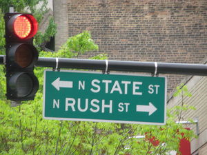
The typical Chicago traffic light assembly is characterized with the basic pole structure, two stoplights, street level signage, and one overhanging sign. The overhanging sign faces motorists arriving at the intersection, lists the cross street, address, and requisite half of the city. The street name is always in the larger font and is synonymous with the fact that Chicagoans rarely identify a roadway per its number identifier, direction, or suffix.
For example all streets meeting Illinois route 19 – Irving Park Road will encounter “W. IRVING PARK Rd. – 4000 N.” Logically, this section of Irving Park Road is west of State Street and all addresses north of this intersection will be higher than 4000. In Chicago parlance, this is “Irving Park” or “4000 North.”
Commuters driving north along Halsted Street will note decreasing numbers towards downtown and Madison and increasing addresses away from the city. Let’s begin our trip at 87th Street and Halsted on the South Side headed north past the Loop. We are west of State Street and signage will read “W. 87TH St. – 8700 S.,” “W. 35TH St. – 3500 S.,” and ultimately “W. MADISON St. – 0N. / 0S.,” before transitioning into the North Side. We will then encounter “W. NORTH Ave. – 1600 N.” and “W. FULLERTON Ave. – 2400 N.”
Cross-town east to west traffic light assemblies prove that these routes are equally as logical. South Siders moving along 95th Street will hit “S. STONY ISLAND Ave. – 1600 E.,” and “S. COTTAGE GROVE Ave. – 800 E.,” before crossing over into the western half of the city at “S. STATE St. – 0N. / 0S.”
Chicago Loop traffic lights rest at each corner of the intersection and do not feature the aforementioned overhanging signage. Still, locals and tourists will easily come to recognize the distinct downtown street names that are synonymous with U.S. Presidents and pillars of Chicago lore, such as Washington, LaSalle, and Dearborn.
Chicago Street Guide and Grid: Interstate Overlay
Chicago, population 2,896,016, is a vital node of commerce, culture, and transportation ideally situated between the Great Lakes, St. Lawrence Seaway, and the Mississippi River. Naturally, all Midwest roads lead to Chicago, and the Windy City may be accessed by Interstates 55, 57, 90, 94, and 290.
These routes converge together at the Chicago Loop in what I may describe as a multiplex spinal pattern that is shared by both Milwaukee and Atlanta. Interstate traffic is funneled into I-90 / 94 and bisected by I-290 at the Chicago Loop. This design is similar to Atlanta’s I-75 / 85 Downtown Connector and I-20 interchange.
Interstates 57, 90, and 94 meet at the South Side and I-90 / 94 – Dan Ryan Expressway is located just west of South Street as it approaches downtown. The Dan Ryan transitions into the I-90 / 94 Kennedy Expressway north of the Circle Interchange with Interstate 290 and shifts to the northwest, largely tracked by Milwaukee and Elston Avenues.
I-90 and I-94 split yet again shortly after IL 19 – Irving Park Road – 4000 N., with I-90 maintaining the Kennedy nameplate going west towards O’Hare Airport. I-94 then becomes the Edens Expressway, paralleling Lake Michigan via the Tri-State Tollway into Milwaukee.
Although Interstates 90 and 94 geographically barrel through Chicago from north to south, these highways are actually signed as “East” and “West” due to the fact that the two northerly interstates carry traffic from Seattle, Minneapolis, Milwaukee, Chicago, Detroit, and Boston. Interstate directional signage is often accompanied with “Indiana,” “Wisconsin,” or “Chicago Loop” listings that should alleviate the confusion.
Interstate 290 – Eisenhower “Ike” Expressway links the West Side of Chicago to the Loop via right-of-ways that are just to the south of Madison Street. I-290 signage typically reads “West Suburbs” or “Chicago.” Interstate 55 – Stevenson Expressway is a southwesterly route into the city from the Mississippi River and points south of St. Louis. The Stevenson ends at Lake Shore Drive in the South Loop.
The iconic Lake Shore Drive is predominately signed as U.S. 41 and obviously traces the shores of Lake Michigan.
These expressways may be accessed from all major 800 streets. The interchanges are usually of a diamond style with traffic lights at street level leading towards the on ramps. Of course, these important traffic light assemblies will be marked with Interstate shields and overhanging signs identifying the neighborhood address and Expressway nameplate.
Chicago Street Guide and Grid: Public Transportation Overlay
Chicago Transit Authority (CTA) Trains and Metra Commuter Trains share right of ways with several of the aforementioned corridors. Again, all train lines converge downtown at the Chicago Loop and public transportation is acutely visible from several Windy City reference points.
Metra Rail lines generally follow the Kennedy, Interstate 55, Lake Park Avenue, Vincennes, Ogden, and U.S. 41 – South Shore Drive into the city.
The Blue, Pink, Orange, Purple, Brown, and Green Lines encircle Chicago’s commercial core in a “Loop” formation along elevated tracks overhead Lake, Wabash, Wells, and Van Buren streets.
The CTA Blue Line traces the median of the I-290 Eisenhower Expressway before burrowing beneath Dearborn Street as a subway and reemerging due northwest to O’Hare Airport via Milwaukee Avenue and the Kennedy Expressway.
The Pink Line is a former branch of the Blue Line that parallels Cermak Road before sharing track with the Green Line at Ashland into the Loop overhead Lake Street. The Green Line turns sharply to the south at the Chicago Loop and remains within close proximity to State Street and King Drive before servicing 63rd Street on the South Side.
South Siders may also access the Orange Line from Midway to downtown along Archer Avenue and the Red Line into downtown anywhere along the I-90 / 94 Dan Ryan Expressway.
North Side CTA Brown, Red, and Purple Lines largely follow Sheridan Road, Broadway, Sheffield, and Lincoln Avenues before arriving downtown. The Red Line is the most important route, with 24-hour service from Howard to 95th Street / Dan Ryan via the State Street subway underneath the Loop.
The CTA prominently features street coordinates at every stop. For example the Red Line Grand stop at Chicago Avenue and State Street is marked as “CHICAGO – 800 N. – 0E. / 0W.”
Chicago Street Guide and Grid Summary
Chicago really is the City that Works.
The street guide and grid is completely logical, almost to the point of sheer madness.
Certainly, if all else fails, simply locate the Sears Tower and Chicago skyline, head towards that direction; and make a left at Lake Michigan for the North Side, or a right turn to find the South Side.
Chicago Street Guide and Grid, Sources:
The Official Web Site of the City of Chicago, http://www.cityofchicago.org/city/webportal/home.do
Chicago Home Estates, Chicago Street Guide, http://www.chicagohomeestates.com/info/chicago_street_guide
Chicago Neighborhoods, Chicago Street Guide, http://www.chicagoneighborhoods.cc/chicago-streetguide.html
Chicago Transit Authority, http://www.transitchicago.com/
Metra Rail, http://www.metrarail.com/