Miami is the biggest small city in America. Miami proper sits upon a speck of Dade County land between the Everglades and Biscayne Bay. The city limits span a scant 35 square mile area that is home to roughly 425,000 people. Miami is actually the second largest city in Florida after Jacksonville (794,555).
Of course, the larger metropolitan area, which includes Miami – Dade, Broward, and Palm Beach Counties has emerged as the fourth largest population center in the country after New York, Los Angeles, and Chicago. According to U.S. Census Data, these South Florida municipalities account for 5.5 million inhabitants.
Miami is easily the smallest core city of any U.S. metropolitan area totaling over 2,500,000 residents. Miami is not to be confused with Miami Beach, which is a separate locale altogether and does actually house the South Beach and Art Deco District. Miami Beach is across the Biscayne Bay at Florida’s chain of barrier islands.
Miami is America’s Gateway to Latin America and the Caribbean.
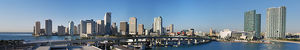
Said prominence is the rationale behind Miami’s imposing cultural stature, relative to its smallish size. The metropolitan area is predominantly 5-10 miles wide, yet over 70 miles from north to south. The urbanized area is constricted by the Everglades and Atlantic Ocean. This fusion of tourists, balmy weather, celebrity draw, and international Mecca transform the Miami area into a movie set that is synonymous with an escapist outlook upon life.
Although Miami is not typically connoted as a transportation hub, the Port of Miami is one of America’s leading trading hubs. In fact, the Port of Miami is the most utilized destination for cruise ships in the entire world.
Obviously, the general navigation of city streets will always be helpful for locals, internationals, and the crushing amounts of tourists that descend upon South Florida annually.
Miami sits upon a flat coastal plain that makes for a relatively easy understanding of the city streets and highways. The city does appear to “melt” into the surrounding areas. Traffic light assemblies, landscaping, and the highway engineering are virtually homogenous throughout Miami and South Florida.
Stop light fixtures are black and may dangle from wires or be directly affixed horizontally to poles. Unique lane markings will also alternate from black to white as a stark contrast upon the concrete. This is not Chicago or Washington, D.C., where city limits are clearly marked by unforgiving layouts and road architecture variance that is distinct from the neighboring suburbs.
The delineation of the city limits is made ever more hazy by a jagged border that is bookended by large swaths of unincorporated Dade County.
Still, Miami proper is traversed by a regular city grid and pattern of principal routes that include Florida 112, Florida 836, U.S. 1, and I-95.
Florida state routes are identified with white and black re assurance shields that post the numerical marker over the Florida political map. Florida’s Turnpike carries a hidden Florida 91 numerical assignment and is often marked by green signage featuring a Florida emblem that maps the highway.
U.S. Routes may display funky color-coded signage over the iconic banner. For example, the U.S. 1 shield sometimes appears as red over white. Florida ceased the practice in 1993.
This guide will detail the Miami street grid and South Florida’s principal highways.
Miami Street Guide and Grid: Miami and Flagler is Ground Zero
The Miami street grid begins at Flagler Street and the appropriately named Miami Avenue.
Flagler Street is in reference to railroad baron Henry Flagler. Flagler emerged as the right-hand man of John D. Rockefeller and is historically acknowledged as the Father of Miami. The tycoon actually persuaded locals to name the 1896 terminus of his Florida East Coast Railway “Mayaimi,” after its old Native American name, rather than “Flagler.
Flagler Street runs east to west and Miami Avenue is the north-south meridian. These two streets meet downtown and divide the city into Northwest, Northeast, Southwest, and Southeast quarters. Logically, Miami and Flagler retain North, South, East, and West cardinal prefixes. For example, Flagler Street west of Miami is W. Flagler, before transitioning into E. Flagler upon the other side of this divider.
Numerical streets run predominantly from east to west; and numerical avenues run from north to south. Streets and avenues do arrive in parallel pairs and are differentiated by prefix. Two distinct 2nd Avenues enclose Miami Avenue. The 2nd Avenue to the west of Miami Avenue will be identified as “NW 2nd Avenue” or “SW 2nd Avenue.” NW 2nd Avenue would be the section of this roadway that is north of Flagler and west of Miami Avenue.
SW 1st – 9th Avenues do veer off course to track a southwest-northeast path through the Coral Way section of Miami, which parallels the Biscayne Bay coastline. Interestingly, numerical roads also bisect this neighborhood. SE 15th Road, SW 12th Avenue, and the Vizcaya Museum enclose this small shift in alignment.
The Flagler – Miami intersection is relatively close to the Biscayne Bay waterway. Hence, NW and SW prefixes largely cover Miami. The Miami grid does extend into Dade County. However, Hialeah and Coral Gables are off of this layout. Hialeah features its own numerical reference point and Coral Gables is identified with numerous cul de sacs and unique street names.
Today’s prevailing Miami – Dade road nomenclature arrives in response to a U.S. Postal Service mandate to mitigate the confusion of a cornucopia of randomly named streets.
Hence, several major roadways often cite two different names. These quirks include Coral Way – SW 22nd Street, Douglas Road – SW 37th Avenue, and Le Jeune Road – NW and SW 42nd Avenue.
Of course, SW 8th Street into Little Havana is referred to as “Calle Ocho.”
Miami Street Guide and Grid: Address Overlay
The Miami address system is perfectly logical and easy to follow and coordinate due to sequential streets and avenues. The primary difficulty arises by mastering the fact that Avenues run north – south and Streets track east to west. In time, visitors will also be able to match the numerical street and nameplate of all principal routes, such as the aforementioned Le Jeune Road / 42nd Avenue.
For example, 500 NE 2nd Ave would represent the corner of 5th Street and 2nd Avenue that is downtown and northeast of the critical Flagler – Miami intersection.
The 70-story Four Seasons Hotel Miami, the tallest building in Florida is located at 1441 Brickell Avenue. Miami veterans will recognize this as SE 14th Terrace at U.S. 1 – just south of Central Miami.
Let us now introduce Miami’s principal routes and interstate overlay for the uninitiated.
Miami Street Guide and Grid: Principal Routes and Interstates
Through east-west streets are generally spaced by the mile.
Principal north-routes do arrive in blocks of 5. NW / SW 7th (8th), 12th, 17th, 22nd, 27th, 37th, and 42nd Avenues are major surface roads. FL 953 – 42nd Avenue is a cutoff to Miami International Airport from Coral Gables and also carries the Le Jeune Road identifier.
The iconic U.S. 1 begins at Key West and follows the Atlantic Coast to Maine.
U.S. 1 through Miami remains within close proximity to the Biscayne Bay shoreline. Route 1 is signed as “S. Dixie Highway” through the Dade County suburbs and into the city limits. S. Dixie Highway is replaced with a Brickell Avenue nameplate at Vizcaya and into the Central Business District from the south. U.S. 1 then carries a Biscayne Boulevard nameplate through downtown and to points north.
Route 1 “births” I-95 at Miami. Interstate 95 is the most important highway in the world.
I-95 is referred to simply as “95” or “The I” by locals. I-95, U.S. 1, and FL A1A track the Atlantic Coast and are the principal thoroughfares connecting Dade, Broward, and West Palm Beach counties. Florida’s Turnpike mainline begins at the critical Golden Glades interchange and also carries north-south traffic through the metropolitan area, before heading northwest to Orlando. Ominous “Hurricane Evacuation” signage lines this route.
I-95, Florida’s Turnpike, FL 826 – Palmetto Expressway, U.S. 441, and FL 9 all meet at the Golden Glades, which is directly to the north of Miami. FL 826 is referred to by locals as “The Palmetto” and is the primary belt perimeter to navigate the inner Dade County suburbs. Interstate 75 meets the Palmetto outside of Miami and is signed as “North” and “South.”
I-75 does cut directly west across the Florida Everglades, but is generally a north to south route between Michigan and Florida.
Lastly, Florida state routes 112 – Airport Expressway and 836 – Dolphin Expressway bisect the City of Miami from the airport area towards downtown. These east-west roads are tolled and highlighted by a “TOLL” banner affixed to all signage. FL 112 and FL 836 do transition into I-195 and I-395, which span the Biscayne Bay into Miami Beach.
Miami Street Guide and Grid: Biscayne Bay Crossings
Miami bridges are actually causeways, or roadways that have been built upon elevated sandbanks.
These causeways are the John F. Kennedy, Julia Tuttle, Venetian, MacArthur, and Rickenbacker. The various causeways connect Miami to separate barrier islands at the Atlantic Ocean. Specifically, the tolled Rickenbacker connects the exclusive Key Biscayne to Miami, while the various other causeways link up with separate sections of Miami Beach. I-95 and U.S. 1 intersect all Biscayne Bay spans.
The Julia Tuttle Causeway, honoring the Mother of Miami, carries I-195 from Miami to Miami Beach.
The MacArthur Causeway is signed as I-395 / U.S. 41 and deposits South Florida motorists directly into South Beach. This route also grants access to Star Island, home to Shaquille O’Neal and P. Diddy. The MacArthur Causeway, with its sweeping views of Biscayne Bay, the Port of Miami, and the South Florida skyline is a media stalwart, particularly for hip hop music videos.
This is definitely the Playground of all celebrity.
Miami Street Guide and Grid: Public Transportation Overlay
Miami is too cool for an extensive public transportation rail system.
One elevated track line follows U.S. 1 at FL 826 – Palmetto Expressway from Kendall into the City of Miami. The Miami – Dade County Transit Metrorail then enters downtown via SW 1st Avenue and cuts west at Overtown along NW 11th Street. From there, the Metrorail traces NW 12th Avenue between NW 14th Street to NW 36th Street.
Although this line eventually meets and follows FL 112 – Airport Expressway, Miami’s Metrorail service does not continue onto the airport. The line branches off from the expressway and tracks FL 9 – NW 27th Avenue to NW 79th Street. Miami’s train enters Hialeah via FL 934 (NW 79th St. / E. 25th St.) and terminates at the Palmetto Expressway.
This is a 45-minute end-to-end ride along roughly 10 miles of track applicable to the fourth largest metropolitan area in the United States of America.
What? You mean you don’t own a Ferrari?
Miami Street Guide and Grid, Sources:
The City of Miami, http://www.miamigov.com/cms/
Miami Guide, http://www.timeout.com/miami/features/14/miami-area-guide
The Official Web Site for Florida Travel, http://www.visitflorida.com/
")
")
")
")
")
")
")