In order to start visiting ancient monuments of the world with Google Earth, you will first need Google Earth installed on your computer. If you don’t currently have it, it is easy to acquire. First go to the Google Earth homepage, found at http://earth.google.com. Click on the Downloads link on the left side. Then, click on the version of Google Earth that you desire. (Google Earth is free, but Plus and Pro are not. There is now also a Google Earth for Mac users). The just download the program, install and you are ready to fly!
When using Google Earth there is an excellent search feature that instantly transports you to any spot on the globe. These searches can be done in one of two ways: typing in the name of a city and country, or entering the decimal coordinates of its location. (Google Earth does not use degrees, minutes and seconds to find latitude and longitude). For these ancient monuments we will have the decimal coordinates of the locations. Simply copy and paste them into the Google Earth search and you will find yourself looking at some of the most ancient and precious monuments of the world.
The Great Sphinx of Giza Country: Egypt Coordinates: 29.97529, 31.137496
The Great Sphinx of Giza is one of the most recognizable landmarks of the world. Standing in the shadow of the Great Pyramids (which can be seen on Google Earth just to the west of the Sphinx), was built in the Egyptian 4th Dynasty bythe Pharoah Khafre sometime in the 3rd millenium BC.
Best known for its missing nose (and also a missing beard that is not as often discussed), the Sphinx spent most of its existence buried in sand up to its neck, with only its head exposed. At the turn of the 20th century a great reconstruction began. The statue was dug up and restored, and can now be seen in all of its glory.
From the vantage point of the Google Earth satellite you can easily see its full shape, the lion’s body at rest. It is topped by its badly misproportioned head, too small for the massive body. Most scholars believe this head is carved in the image of Khafre, for whom the statue was built but many other theories exist as well.
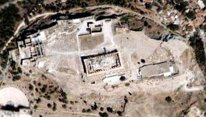
The Acropolis of Athens Country: Greece Coordinates: 37.971389, 23.726667
In ancient Athens few sites held more significance than the Acropolis (high city), best known for the Parthenon built 2500 years ago during Athens Golden Age. The Temple is dedicated to the Goddess Athena (for whom Athens is named), and is one of many temples built upon the Acropolis.
When looking from above with Google Earth, the Parthenon is clearly visible. It is near the center of the hill, and is the largest structure visible. Even from such a high height you can see the columns which once held its massive roof.
Other buildings visible include the Propylaea and the Temple of Athena Nike.
The Colosseum of Rome Country: Italy Coordinates: 41.890169, 12.492269
Originally known as the Amphitheatrum Flavium, the Colosseum was built by the Emperors Vespasian and Titus in the latter half of the 1st century AD. It was the largest amphitheater built in the Roman Empire, and remains an impressive feat of architecture to this very day.
In this massive building countless combats and games took place, the largest center for gladiatorial combat in the world. When looking down at the Colosseum from Google Earth you can just imagine the building populated with thousands of fans, watching as gladiators fought for their lives against vicious beasts and even more vicious fellow competitors.
The Colosseum remained in use for centuries before the games were finally put to an end under Christian rule of the Roman Empire, even battling massive damage incurred from two earthquakes in the 5th century. During the time of its use it is estimated that hundreds of thousands of people were killed in games at the building.
The Nazca Lines Country: Peru Coordinates: -14.71, -75.18
In the middle of the Nazca Desert, between the towns of Nazca and Palpa in Peru stretch a vast number of massive lines scratched into the earth. Only visible from the air, the lines went unnoticed until the 1920’s when they were spotted by people passing over in airplanes.
While many of the lines are little more than lines, there are also a number of large images drawn into the earth, including a spider, a hummingbird, a monkey and a lizard among others.
Little is known about the Nazca people who created these lines, or why they might have made them. Many theories have developed over the years but there has yet to be anything definitive said on the subject and remain a great mystery. It is estimated that the lines were formed sometime between 200 BC and 600 AD.
The Pyramid of the Sun at Teotihuacan Country: Mexico Coordinates: 19.692, -98.844
The Aztecs of Pre-Columbian Mexico are best known for the great city of Tenochtitlan (modern day Mexico City), but they were also the builders of the equally impressive Teotihuacan, about 25 miles to the northeast of the Aztec capital.
The most impressive building of ancient Teotihuacan is the Pyramid of the Sun, the second largest building constructed in Pre-Columbian times in Mesoamerica. Its great size can clearly be seen from Google Earth, and it is truly an impressive sight to behold.
It was constructed in two phases, the first beginning about AD 100. This phase was responsible for the majority of the construction, although the alter top among a few other adjustments to the building were made in the second phase sometime during the 3rd century AD.