With a drought plaguing much of the U.S. this past summer, it was comforting to be able to go back to the Spokane, Washington, area for hiking; and thus, take in lush and lively greenery plus more of Mother Nature’s offerings. I hiked three areas easily accessible from Spokane, being challenged on one, getting quite a nature lesson during another, and acting on my love of railroads in yet another.
I attended a press trip sponsored by Visit Spokane, but my observations below weren’t vetted by my hosts.
Even though I find a good hike challenging, I am a novice when it comes to plants and trees, so it’s always a privilege to hike with an expert like Washington State Park Ranger Audra Sims. She knew the names of many of Mother Nature’s offerings as we jaunted to the confluence of the Spokane and Little Spokane Rivers in Riverside State Park. The park has some 12,000 acres. It’s so big that the driving loop for the ranger is now 50 miles, covering three counties.
While no structures exist at the confluence, roughly 15 miles from downtown Spokane, this spot is where the first white settlement in Washington was situated in 1810. It was a fur trading post known as the first Spokane House, set up by the North West Company.
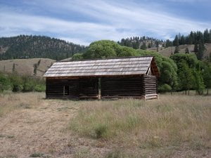
Our hike commenced near another historical structure in the northwest part of the park, a Lincoln-Log-like hay shed, which is considered one of the oldest still-existing structures in the state. It was built in the 1870s, and original logs still can be seen, though the roof and bottom have been subsequently repaired with newer materials. It served as a grain threshing spot for both settlers and Native Americans in a land that was shaped by lava flows, Ice Age glaciers, and the Missoula Floods 15,000 to 13,000 years ago.
Throughout the hike on a warm, sunny day with temperatures in the 80s, Ranger Sims pointed the various trees and other plants we came upon or near to, including Ponderosa Pine, Douglas Fir, wild roses, Snowberries, and even some noxious weeds (which drive out native plants affecting the food supply for animals) like Canada Thistle and Blueweed. Moose, mountain lions, eagles and ospreys have been spotted by visitors.
Ranger Sims commented that if we saw a Black bear, we should be assertive and loud, unlike with grizzlies, where one should play dead. Nonetheless, we were treated with the sweet scent of the sap running from the Ponderosa Pines.
As we got closer to the confluence, our relatively flat hike stayed flat, but the pathway became obstructed by Elephant Ear Plants until we got to the peaceful emergence of the two rivers as they flowed into Lake Spokane. It’s not been determined where the exact spot of the original Spokane House was, but by getting to the confluence, we traipsed in the steps of fur traders past.
Afterward, we ventured a short ways south to what is considered “Spokane House” on the park map, since archeologists have been able to identify the whereabouts better to where the structural boundaries have been marked for visitors to see. It was founded in 1812 by the Pacific Fur Company as a fur trading post, too. Right next to this spot, the Spokane House Interpretive Center offers visitors more historical information. It’s open normally on weekends from Memorial Day to Labor Day and by appointment. Contact the state park for more details.
Over the course of two hours, I took one of my most challenging hikes ever. I traversed the long and winding pathways on Tower Mountain’s east flanks contained in the 966.62 acre Iller Conservation Area, one of the newer acquisitions of Spokane County’s park system that’s some 20 minutes drive south from downtown Spokane.
Knowing that bears have been spotted in the area, I kept hoping we wouldn’t have any run-ins with this mammal, one of 15 mammals that are known to reside there (including moose and coyotes). Furthermore, we had the trail pretty much to ourselves, though we had the soundtrack of various songbirds to enjoy.
Luckily, the only notable creatures we came across were a garter snake crossing the trail road and a camera-shy white-tail deer, who disappeared into the plantlife, dominated by Ponderosa Pine and Douglas Fir trees higher up as well as a litany of green, red, yellow, and purple flora.
As we ascended toward the summit, we came into view of some nearby rock formations known as the Rocks of Sharon. These granite rocks make for challenging climbs by enthusiasts.
The 90 degree-plus heat only added to my challenge, but thanks to a large bottle of water, some welcome gusts of wind, and my trusty walking stick, I was able to meet the challenge of those arduous five-plus-miles. At the summit, I got some stunning views of the surrounding areas from 3,600 feet, including the Spokane Valley, the city of Spokane, and other distant peaks.
Because this hike features paths that ascend 35 to 45 degrees many times over trails that contain ruts, it’s recommended that one be in good shape to participate.
Hiking where once trains ran through
The Turnbull National Wildlife Refuge covers approximately 16,500 acres of off-the-beaten-track land that was formed by the Ice Age floods. It’s around 40 minutes’ drive from the hustle and bustle of downtown Spokane. Turnbull is full of grassland, forests, and deep permanent sloughs (or wetlands) and isolated, little, and temporary wetlands, known as vernal pools. Ponderosa Pine and Aspen forests make up part of the natural offerings.
Despite its size, only a fraction of the refuge is open to the public, some 2,500 acres, where over 200 species of birds have been seen, along with, ducks, elk, mule-deer, coyotes, beavers, and river otters. Twelve species of bats, seen after dark, also reside here as they’ve found a home in the basalt rock crevices.
Before hiking, we were interested in taking a scenic drive on the five-mile Auto Tour Route that circles the northern part of the public use part of the refuge, where we saw several walking trails verge off the road to various lakes while taking in the scenic beauty of the Ponderosa Pine and Aspen forests. We got out at the Kepple Peninsula Interpretive Trail to do some hiking. A family of trumpeter swans could be seen in the distance on a warm, breezy morning.
See the website above for more information about fees, interpretive displays, trail descriptions, and various activities allowed throughout or part of the year.