Since Google Inc. purchased “Earth Viewer” from Keyhole in 2004, Google has transformed a piece of professional cartography software into a program that everyone and their grandmother can use, and play with until it’s four hours later and you’re still looking at where your second-cousin twice-removed’s next-door neighbor lived three decades ago. With its new release, Google has made America’s newest past-time even better.
For those un-familiar with the software, Google Earth is mapping software taken to the next level. The interface is the Earth it self, you can zoom in and view your own house, and possibly your car as well! You can re-orient the maps in any way imagine, through panning, rotating and zooming. Google even shows topography in some areas, as well as three dimensional buildings in some of America’s major cities.
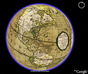
In its most recent release of Google Earth, version 4, it has made a number of improvements sure to bring joy and steal even more of your time. Perhaps the most entertaining of the updates includes the ability to lay historical maps over sections of the globe and view the world in the fourth dimension, time. However, the software can leave the existing road-ways and buildings so one can compare what’s there now, and what was there before. The maps are provided to Google by the David Rumsey Map Collection. One such map included in the software is the map created by the Lewis and Clark expedition. Additional maps not listed in the software are available from the David Rumsey website.
Another new inclusion is its greatly improved printing capability. The new printing module allows users to print up to 4800 pixel images, which is about 11″x17″ on paper. Users can also print search results, folders of place marks, in addition to the three-dimensional view and driving directions.
Users in the country of Japan have also greatly benefited from version 4. The software now has full Japanese language support and layer data for the country of Japan. This means that where users only saw the three dimensional imagery before, now they can see the overlays of businesses, roads, schools, landmarks and much more.
Google Earth’s interface has received some minor tweaks in its latest version. Google created new icons for the pushpin and user palate, a featured content layer, a new interface for time-stamped image overlays, and new KML folder options.
A number of other minor features have been included in this update, such as high definition movie creation in the pro version, performance improvements, a coordinate grid overlay system, improved driving directions and support for the web mapping service.
In the new version, Google has added a number of interface improvements and content additions. Google Earth has turned a great piece of software into something even better.
Reference:
- Google Earth (Official Website) Google Earth (Wikipedia) Merge Historical Maps With Current World In Google Earth (SEW)


