I lived in the Fort Collins area for about five years and spent a lot of time hiking on the trails in and around the area, as well as belonging to a popular northern Colorado hiking club.
Here are my five favorite day hikes in the area.
Horsetooth Rock trail in Horsetooth Mountain Park is 3.2 miles one way and a great hike that can be done within a few hours but you still feel like you’ve gotten a lot of exercise!
Driving Directions To Trail-head: From Harmony Road in Fort Collins, proceed west past Taft Hill Road, this turns into CR 38E. Follow this road around Horsetooth reservoir, about 6 miles from the Harmony/Taft Hill intersection, to the Horsetooth Mountain Park parking lot. The daily entrance permit is $6. The parking lot can get full on a busy summer day by the afternoon. I would recommend arriving before 11am to ensure a spot. There are restrooms and running water in the parking lot; however, be sure to bring a lot of water on your hike as it can get quite hot and is typically very dry. There is an information sign, and the trail for hikers only is to the right of the sign. The trail to the left is the mountain bike trail.
The Horsetooth Falls hike and Horsetooth Rock hike are on the same trail for 1/4 mile of the way, then Horsetooth Rock splits off to the left, while Horsetooth Falls continues straight (rarely is there actually much of a waterfall on that hike in case you decide to try it instead). In the beginning the trail is fairly easy, but it does become quite steep. You will be rewarded with beautiful views of Fort Collins, the plains and the surrounding foothills after winding through a forest. You will not see Horsetooth Rock until you are right below the summit.
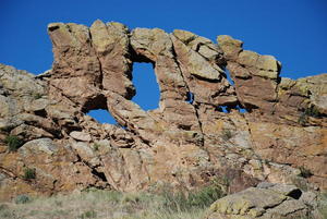
Devil’s Backbone (Ravens Roost/North Loop) is in Loveland, just south of Fort Collins. The Ravens Roost trail is just 2.5 miles round trip but you can continue onto North Loop for another 3.5 miles. The elevation gain is just 200 feet. The parking lot is small so be sure to arrive early! This is a perfect hike for late winter/early spring when there is still too much snow in the hills and you really want to get outdoors.
Driving Directions To Trail-head: The trail-head is 2 miles west of the intersection of Wilson and Eisenhower in Loveland- off Hidden Valley Drive. There are plenty of signs as well. Especially in the summer, be sure to bring plenty of water as it can get quite hot here and there is no shade. During other times, wear hiking boots that you don’t mind getting muddy.
The Devil’s Backbone is an eroded rock formation, and there are several arches formed within it as well- perfect for picture taking. There are beautiful views and the rock formations are unique and impressive. Wildlife abounds- you might spot mule deer, elk, bobcats, fox or coyotes. Ravens, prairie falcons, golden eagles, red-tailed hawks, and great horned owls have also been seen in this protected habitat.
Greyrock Mountain trail is northwest of Fort Collins in the Poudre Canyon in Roosevelt National Forest It is a 7 mile round trip moderate hike. There is a well marked parking lot. If you arrive before 11am you should be able to find a spot.
Driving Directions to Trail-head: From Ted’s Place on Highway 287 and Highway 14, drive 9 miles west on Highway 14 to the parking lot on the south side of the road. This is a loop that meanders through meadows and ponderosa pines perfect to provide you with shade for a quick rest. The last stretch is quite challenging. Be sure to follow the cairns, used as trail markers. At the summit you will be rewarded with views of Fort Collins, the plains and the Rocky Mountains.
Young Gulch is another great hike in the Poudre Canyon, northwest of Fort Collins. It is 9 miles round trip and an easy to moderate hike, rising 1,000 feet in elevation. Snow can be found well into spring as much of the canyon is shaded.
Driving Directions to Trail-head: From Ted’s Place at Highway 287 and Highway 14, drive west on Highway 14 into the Canyon and about 2.75 miles past Poudre Park. The parking area is on the left right across from Ansel Watrous campground. Arrive before 11am on a busy summer day, otherwise you should not have a problem arriving anytime.
This is a very nice trail, winding along a creek. It starts out fairly level in a meadow with ample wildflowers and then leads into the tress about a 1/2 mile in. If you hike during late spring, you can find a small pool in the rocks with a beautiful waterfall flowing into it. The last mile does get quite steep, and if there is still snow on the ground it can slow you down a bit.
The last hike is a little farther away, but well worth the drive and the incredible scenery!
Gem Lake is one of my favorite hikes! It is close to Rocky Mountain National Park; however, you do not go through the entrance. This hike is 3.7 miles round trip with a gain of 1,016 in elevation. It is a moderate hike.
Driving Directions to Trail-head: From Loveland, take Highway 34 toward Estes Park. Continue on Highway 34 passing the Stanley Hotel, then head north on McGregor Ave 1.6 miles and watch for the sign for Lumpy Ridge Trail-head. Turn north and follow it to the parking lot. Beginning the hike, you’ll view beautiful granite domes and then spectacular views of Estes Park and the mountains. The second half of the hike is quite rocky; however, the rocks are almost like stairs leading to Gem Lake. The lake sits between sheer granite cliffs and it is truly breathtaking.


