In the early part of 2008, my wife Jacqueline and I spent a couple days on Hawaii Island (aka the Big Island) in Kona. We had a nice visit to Kona, Hawaii temple (we are LDS). We also took time to go hiking. I’ve never hiked in the Kona area, so prior to our trip I googled “Kona Hawaii hikes” and found out information about a 4+ mile hike to a monument for Captain James Cook at Kealakekua Bay.
For those who don’t know Hawaiian history, Captain James Cook, who in 1778 was the European to make landfall in the Hawaiian Islands, which were populated by several hundred thousand Hawaiians at the time. Anyway, Cook was killed at Kealakekua Bay by Hawaiians who, according to some accounts, may have thought that he and his crew were overstaying their welcome. For a detailed rendering of that event in history, read more here.
http://www.captaincooksociety.com/ccsu2531.htm
The trail we hiked led down to the monument for Cook, which marks the spot on the rocky shoreline of Kealakekua Bay near where the British navy captain met his demise.
From the Big Island’s tourist mecca, Kailua-Kona, we drove 14 miles south on the main highway. At a sign on the main highway for “Kealakekua Bay” we headed right on Napoopoo Road. I remembered from my google search that the trailhead was on the right within a hundred yards from the main highway on Napoopoo Road. After driving past the trailhead initially, I turned our vehicle around and saw a couple people who looked like hikers getting ready to set off.
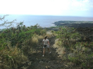
I parked our car along the side of Napoopoo Road at a little turnoff spot right near the main highway and watched where the hikers were headed. Doing this, I was able to locate the trailhead. Note that just past the trailhead, a large house is under construction (circa Jan 2008). Also note that at the trailhead is a “Road Closed” sign. See the picture I have included with this report.
Weatherwise, the day we were there wasn’t the most ideal for hiking because it was drizzly and thunder from a passing storm was booming upslope. But since the weather in this part of the island is usually sunny, I assured my wife that the overhead outlook would turn for the better and while this never really happened, the weather never worsened and we were able to have a good hike.
As for the trail, the initial mile is a steady descent which was never steep. The trail passes thru thickets of wheat-like grass and haole koa, a common dryland tree species in Hawaii. During this part of the hike, there is not much in the way of views.
After that initial mile, the visual aspects of the trail improved considerably and we enjoyed views of the rugged, lava-rock strewn coastline below. After a long steady descent, the route has a couple of distinct switchbacks. At that point, it becomes clear that switchbacks help to avoid a very steep pali (cliff).
Our hike led us to the Cook Monument, a white obelisk about 30 feet high. Offshore, a couple of dive boats were anchored, for the nearshore waters are a favored location for snorkeling, kayaking, and underwater exploration.
A few years ago, my wife and I went on one of these snorkeling cruises but we were unable to come ashore to explore, so yesterday’s hike gave us an opportunity to visit this spot firsthand, to get some exercise, and to save some money (hiking is free!).
Because we had a dinner with friends to attend, my wife and I didn’t linger long at the Cook Monument nor did we jump in the ocean to cool off. Instead, we headed back up the trail, needing about 45 minutes to return to our car. On the way up, we met a hiking party of 8 to 10 people from England heading down the trail.
Our total hike took us two hours and we now have notched a Kona area hiking experience under our belts. Next time in Kona, we hope to climb to the summit of Hualalai (elevaton 8271 feet).