Orange County offers, per square mile, some of the most gorgeous views of wetlands, the ocean and hilly overlooks in Southern California.
Before we get to the juicy details, it’s important to ensure your safety and safety for those around you, so follow these important tips:
Ride in pairs or groups
Take care around overpasses
Bring a cell phone
Always have water
Follow designated signs and say on the path
Now for the fun stuff…beautifully planned, sometimes well-executed bikeways, bike paths and bike lanes throughout scenic Orange County:
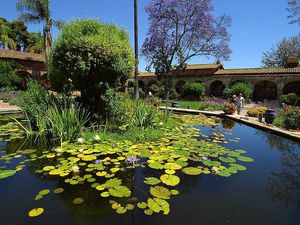
San Juan Creek-Located in San Juan Capistrano, this 4.77 path was completed in April 2010 and runs, uninterrupted, from Doheny State Beach to Descanso Veterans Park. This scenic path offers a variety of sights as well as a varied terrain. Stop at the San Juan Capistrano Mission and rest by the pictured fountain.
Robert McCollum Memorial Bicycle Trail-Short but sweet, the one mile path runs north along the east bank of Trabuco Creek to the south end of Avenida de la Vista. There is access to both sides of Del Obispo Street.
Huntington Beach-An 8.5 mile path runs along the the beach parallel to Pacific Coast Highway beginning at Warner Avenue to the north and ending near Brookhurst Avenue to the south. Cross Brookhurst stoplight and discover the paved Santa Ana River trail which extends over 26 miles through Orange County.
Coyote Creek Bike Path – This well traveled path is on the border of Los Angeles and Orange County and follows the flood control channel through an extremely industrial area. It connects with the San Gabriel River Path and allows most of northern Orange County bike access to the beach. People living in Whittier, which is further inland, really appreciate this commuter friendly-although caution is advised in some areas-path.
Walnut Trail-This 3 mile path begins on the southeast side of Harvard Ave. in Irvine, next to the Metrolink railroad tracks and just southwest of them. Running southeast, it follows the railroad and emerges on Sand Canyon Ave. near the railroad tracks. It crosses Jeffrey Road, and meets Harvard Ave. and Sand Canyon Ave, going Northwest of Jeffrey Road, the path winds through a park-like area. There are a few benches next to the path, and even a drinking fountain, just northwest of Yale Ave.
San Diego Creek-This 44 mile bikeway runs along the San Diego Creek from Jamboree Road in Newport Beach and then joins the Back Bay Loop Trail where San Diego Creek empties into the Upper Newport Bay under the Jamboree Rd. bridge, then follows the creek upstream, crossing much of Irvine before it ends near the junction of the 405 and 133 Freeways.
Back Bay Trail-This 3.38 bike path begins at the downstream end of the San Diego Creek Bikeway on the west side of Jamboree Road in Newport Beach. In fact, it might be considered a downstream extension of that path. At the intersection with Shellmaker Road, Back Bay Drive ceases to be one-way, so the red route ends. However, the rest of Back Bay Drive, all the way to Jamboree Road, has bike lanes.
Salt Creek and Monarch Beach-It might be tough for those new to this 4.81 mile path to follow, so pay attention to the signs. The path begins on the east side of Golden Lantern Street and runs through a large culvert under Golden Lantern Street and then swings north to run roughly northwest on the north side of a canyon that is part of the Salt Creek Corridor Regional Park. The path descends and emerges on Chapparosa Park Road at the entrance to Chapparosa Park.
Whether you want to meander through the park or get quickly to your destination, there is a bike path to suit your needs.
Just remember: Watch the signs and have fun!
http://www.nearfield.com/~dan/sports/bike/river/sg/index.htm
http://www.labikepaths.com/Coyote.html
http://www.sanjuancapistrano.org/Index.aspx?page=29&recordid;=1723
http://www.efgh.com/bike/redrouteorange.htm
http://en.wikipedia.org/wiki/Coyote_Creek_bicycle_path
http://www.traillink.com/viewtrail.aspx?AcctID=6366001


")