By tradition, every New Year’s Day, the Hawaiian Trail and Mountain Club, a 500-member organization based in Waimanalo on the island of Oahu, conducts a hike to the summit of Koko Crater. Access routes have changed over the years. Currently, the route being used by the club is via Kalanianaole Highway, starting at the parking for Halona Blowhole. The up and back hike is just two miles, but there is an elevation gain of about 1200 feet, making for a steep climb and descent. And no, you need not wait till 1/1 to hike this trail. Nor do you need to do it with the club. However, if you are on the island come the end of the year, the club will welcome you to join them.
How to Get There
Starting at downtown Honolulu, drive eastbound on H-1 freeway. Just past Kahala Mall, H-1 ends and transitions to Kalanianaole Highway. Continue east on Kalanianaole, passing Aina Haina, Niu Valley, and Hawaii Kai. Just past the latter, the highway climbs to crest out atop Koko Head, a landmark well-known to locals. In fact, a visitor to the island might hear locals using “Koko Head” as a directional guide rather than “east.
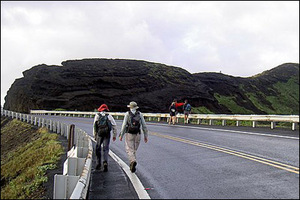
Continue along Kalanianaole past the entrance to Hanauma Bay and a mile later turn right into the parking lot of the Halona Blowhole. Vehicle break-ins have occurred here so take care not to leave valuables in your car.
If you are traveling by city bus, board the #22 bus and get off at Sandy Beach. Walk west (or “Ewa” as locals would direct you) to the Blowhole lot.
Hike Description
From the parking lot, head west (or Ewa) along the mauka (inland) shoulder of the highway. Pass a small gulch on your right. At the far end of the gulch, scramble up the start of a spur ridge. Once you have done that, continue atop the spur. It initially parallels the massive wall of Koko Crater to your right. The spur then bends to the right to connect to the flanks of the crater.
Begin to scramble steeply, proceeding carefully over a rock formation that forms an arch. Cables are sometimes available here for climbing assistance. Test any climbing aids before using. Never put your full weight on any rope or cable.
Continue climbing steeply, heading for the rim of the crater.
Arrive at the crater rim after a 15 to 20 minute climb (more if you have a less-than-average fitness level). Pause here to catch your breath, rest, and admire the views of the rugged, rocky shoreline below and the deep and rough ocean waters along the coast. In the distance, you might be able to make out the islands of Molokai and Lanai. From this vantage point, you can see into the crater. A botanical gardens and hiking trail is located there.
Before proceeding any further, make a mental note of this spot for the return leg of your hike.
When you are ready, head upward along the crater rim, bound for the summit. Be careful, for some sections are narrow and precipitous. Test all footholds and handholds as you proceed.
As you near the top, small trees and vegetation become more prevalent.
Reach the summit of Koko Crater (elevation 1208) at grated metal platform. You can climb atop the platform for a better vantage point.
Plop down and enjoy your lunch or a snack here. Also, enjoy the panoramic views of the surrounding landscape. The community of Hawaii Kai lies below you. Looking westward toward Honolulu, in the distance you can see the famous Oahu landmark, Diamond Head. The park below with many watergoers is called Sandy Beach, one of the popular beaches for bodysurfing and bodyboarding in Hawaii.
Enjoy this hike. Be prepared for some steep up and down scrambling. If this seems a bit much for you, do not hesitate to turn back. At all times, be safe.
Reference:
- Hikers Guide to Oahu (revised edition) by Stuart M. Ball, Jr.