What do these terms mean for us weather-wise and how will the 2012-2013 winter season proceed? Let’s just say that as I type, it’s sleeting like crazy and it’s 38 F in Northern Arizona.
The terms, enumerated above, are names given to semi-regular climactic variations which have an overriding influence on our winters in North America, and worldwide. While The Weather Channel gives great explanations for them, each can involve several textbooks to fully understand. Hence, things get a little complicated. Let’s keep it simple, and call El Nino and La Nina the effects we see periodically, and the “oscillations” the overall causes.
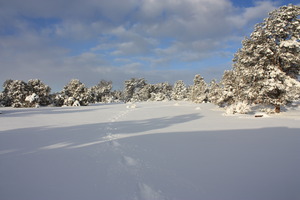
Our weather season has started, according to informal phone calls to technical support representatives here and there, with a decent bang. Iowa said “it’s cold!” The intermountain Rockies saw snow recently. We, in Northern Arizona, just saw the first snowfall on the San Francisco Peaks last night (Thursday, October 11, 2012). Snowbowl Resort atop “The Peaks” states in their radio advertisements that we should see a banner ski/snowboard year. Finally, we in Northern Arizona have seen a “monsoonal” rain season that the locals describe as “incredible.”
How we wish we could have shared all that precipitation with the parts of our nation stricken by drought! And now, it seems, we shall have our wish in some cases; Well, we continue to wish it shall be so!
I have procrastinated, waiting for the evidence of a decent El Nino, that odd little phenomena that causes ocean surface temperatures in the Pacific to rise. I have waited and now see it very well.
The forecast for El Nino is “Light-Moderate,” and this is well documented in several weather discussion blogs from Weather.com and the National Weather Service. El Nino is a comin’!
In simple bullet form, pulled from Accu-Weather, here’s what we might expect:
Expect wet conditions in California. This translates to heavier mountain snows in the Sierras and Transverse Ranges of Southern California. In any recent burn areas, we’ll be considering sandbags!
Expect above normal snowfall in the intermountain Rockies. This is a whole lot better than last winter, which had little or none. Here in Northern Arizona, where it’s between 5,000 to 7,000 feet in elevation, we almost didn’t have a winter. This year, we expect a whole lot of snow.
The East Coast should see a good band of snow from the Mid-Atlantic to New England. Are you dreaming of a White Christmas yet?
The deep South into Florida will likely see cool and moist conditions.
Drier areas in El Nino patterns typically include Oregon, Washington, and the Northern tier of states into the North-Central MidWest.
But what about that drought? The Farmer’s Almanac provides some interesting forecasts, in-line with the above expectations, touted to be 80% accurate according to their site. They have good news for some of our drought areas: improvement. Of course, there’s more predicted on their site and in the Almanac: all worthwhile reading.
So, in summary, the forecast (remember, this is all best-guesswork, and it tries to get the major trends) is looking better for many drought-stricken areas, better for ski operators (and snow plow operators) in the East and West Coast, and a little drier in the Pacific Northwest. Check all the links for details on your area, and watch the skies for El Nino (the “little boy,” in Spanish).


")