Built by the Civilian Conservation Corps back in the depression era, the Waimano Ridge Trail begins above Pearl City and ascends for seven and a half miles to the Ko’olau summit where the reward is a view of Kahalu’u and Kaneohe Bay on the windward side. This trail is one of the better ones in Hawaii.
To reach the trailhead whether you’re a local or a visitor driving a rental car, take H-1 freeway westbound. Exit H-1 at the Pearl City offramp. The offramp will merge onto Moanalua Road, which you will follow to the right (still westbound) to the intersection with Waimano Home Road. Turn right on Waimano Home Road and drive to the top and park your car on the left side of the road just outside of the gate leading to the grounds of Waimano Home itself. A guard shack is there and the guard will prevent further progress by vehicles.
By bus from downtown Honolulu, board bus #53-Pacific Palisades. Exit the bus at the stop at the intersection of Waimano Home Road and Komo Mai Drive. Walk on foot for ten minutes to the end of Waimano Home Road to get to the trailhead.
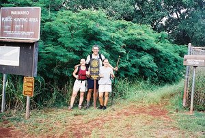
At the trailhead, you’ll see a mailbox/check-in station for hunters on the left and the trail itself skirting outside the fence along the roadway. Sign the hiker/hunter log (good hiking safety practice). Soon after it starts, the trail forks. Take the upper trail to head for the ridge. The lower trail heads down into the valley for a short one hour loop hike.
Waimano is in remarkable condition: it’s wide, level, and easy to traverse. Much of the beginning section of the trail follows a manmade ditch for water. Short water tunnels (these look like caves) can be found at various points along the route. If you choose to go thru these tunnels, carry a flashlight and keep your head low.
In about an hour, the trail crosses a little stream (usually dry) that is a feeder into larger Waimano Stream. Thereafter, the trail climbs gradually to the crest of a spur ridge. Atop the ridge is a covered shelter. This is a good rest spot for hikers bound for the summit or a turnaround point for those looking for a shorter day hike.
For others, push on ahead toward the summit. From the shelter, the trail descends then climbs then descends again to cross rocky Waimano Stream. There are a couple of narrow sections with steep drops to the stream below here. Be careful. Thereafter is a series of switchbacks to gain elevation.
After the switchbacks, the trail contours along the side of the main ridge toward the crest of the Koolaus. This middle section of the trail can get overgrown with scratchy ferns (uluhe), so it is a good idea to wear long pants or gaiters here to avoid the “ouch” sensation you’ll feel during your posthike shower.
The final section of the trail contours on the right side of the ridge. At times you may feel like you are winding in and out of ravines forever, but do not give up. The top will appear soon enough.
Although lengthy (15 miles round trip), the Waimano Ridge Trail can be completed in a day since it is graded and devoid of any major obstacles that may slow your progress. Moving at a steady pace, hikers of even average fitness can reach the summit in about three hours. Plan about the same amount of time for the return leg.
The view into Waihe’e Valley from the summit saddle is wonderful. Also, look for boats cruising about in massive Kaneohe Bay spread below you. A sign at the summit marks the end of the trail. Enjoy!