Here’s an object lesson in cavalier spontaneity. Last Wednesday I had the day off, as did my sister-in-law. I was planning on driving around Boulder, perhaps finding a café, as per my usual habits, to surf the internet and get some writing done. I was standing in my kitchen drinking coffee when my SIL walks in and asks me, “Do you want to drive to the top of Pikes Peak?” I couldn’t think of any good reason not to so I said, “Sure, let’s go.
Pikes Peak is not the tallest mountain in Colorado; in fact it’s ranked #32. At 14,110 feet, however, it’s one of the state’s 56 “Fourteeners” and stands only 323 shorter than #1, Mt. Elbert. It is also probably the most famous mountain in the state and perhaps the Rocky Mountains and one of only two that you can drive to the top of. The reason for Pikes fame is a simple matter of geography. Living in Boulder every day you can step outside and look out on the Great Plains, stretching like a blanket of tawny grass into the eastern horizon and lapping like a gentle sea at the foot hills of the Rockies, a solid wall of rocky stretching as redoubtable dividing line between east and west.
The very flatness of the Plains is what makes them such a great place from which to view the mountains. Well, Pikes Peak is the easternmost tall mountain in the entire range. Looking south from Denver or Boulder you can follow the line of the mountains southward until the horizon. Just to the left of the vanishing point rises a squat, somewhat jagged mountain standing off on its own. That’s Pikes.
The mountain has captured imaginations for centuries. Certainly the Native Americans of the region, the Ute and Arapaho would have known of it. The Spanish called it El Capitan. The slogan “Pikes Peak or Bust!” was one of the great rallying cries of the Old West. Settlers, crossing the Great Plains in search of land, gold or a new beginning, would often spot Pikes Peak first from 50 or 60 miles to the west. To them the mountain symbolized an end to the interminable grasses and was as much a symbol of having reached the West as the Gateway Arch in St. Louis is today. It was to crest this magnificent symbol of American ruggedness that we set out to conquer from the comfortable crushed velvet seats of my Nissan Altima.
We brought a map, a small pamphlet about the area a few Nalgene water bottles, Cliff Bars and warm clothing. We then gassed up the car before heading south. Pikes is about ten miles southwest of Colorado Springs, a straight drive south of Interstate 25. We hit heavy traffic in Denver but otherwise the road is flat, straight and fast with speed limits of 75 mph. Once past Denver the scenery changes from the somewhat Alpine, deciduous prep school feel of Northern Colorado to a much drier, redder and dustier climate evocative of the Southwest. North of Colorado Springs lies the US Air Force Academy, discernible from the tails of airplanes rising from a screen of trees and the football stadium in the distance. After passing through town we headed west along state route 24, climbing into the mountains. We drove past Garden of the Gods, a park filled with fanciful creations of red rock hewn by wind erosion. The road wound around and through cliffs notable for the sandwiches of red and white geologic strata criss-crossing their faces. The gate access to the mountain closes at 3:00; we made it in at 2:30. While paying our $24 entrance fee, we noticed that the weather at the top of the mountain was 29 degrees. At that moment the thermometer in the car read 68.
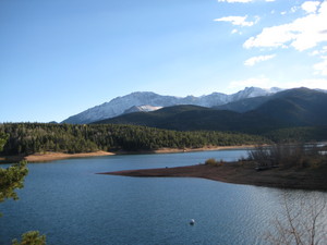
The road up Pike’s Peak stretches 19 miles from the entry gate to the summit. The toll gate stands at 7,750 feet and rises 6,360 feet in total (a vertical climb of about 1.2 miles). Most of the road is paved, with the exception of about two miles in the middle that are hard packed dirt. Signs mark out the miles, the transitions between climate zones and the timberline. After six miles of a gently sloped winding drive we came upon Crystal Lake, a dammed, narrow finger of water with superb views of the mountains. At 9,230 feet, the lake is still well below the summit and looking up from that vantage it seems completely impossible that you will ever make it to the top.
Entering the Alpine and Sub-alpine zones the road began to wind more noticeably with occasional switchbacks. The taller conifers at the base gave way to the stunted and gnarly forms of Bristle-cone Pines, the hardiest and oldest trees in the world. It was in the Alpine zone, at 12 miles into the journey, that we began to see snow on the ground. The temperature outside had dropped into the mid forties and the road became increasingly windy. At mile 13 we got our first up close look at the cliff face. My sister-in-law commented that it looked like chocolate covered with frosting. I could spot the cuts where the road ahead would take us as well as the long ridge of the final climb to the summit.
Above tree line the shrubbery gave way to tangles of small, reddish rocks. The snow deepened into drifts in some places. The road became steeper with nerve wrecking stretches along sheer drops of several hundred feet. Nevertheless, the road is banked into the mountain and is wide with shoulders of a few yards and guard rails at the most precarious turns. Most of the cars that we saw were coming down the mountain. A few were pulled over at vantage points overlooking the surrounding countryside. The last three miles were straighter, following the spine of the mountain toward the summit. We got our first glimpses to the south and west of the mountains. We were higher than the neighboring peaks but in the distance the whole mountain range is an unbroken wall stretching forever. Outside the temperature dipped into the 30’s. The air was noticeably thin, making us both slightly lightheaded. The sun, however, was shining and it was a very beautiful day.
Reaching the summit we saw a small sign stating “You Made It! 14,110 Feet.” Strangely, after climbing all that way, the summit itself is a rather prosaic dirt parking lot with a few dozen cars of travelers enjoying the view. When I stepped out of the car I got a bit of a head rush and was struck by the bitterness of the cold, which I had not felt since the previous winter. First we made for the observation tower on the southeastern face. The views of the mountains and the plains are stunning. One plaque informed us that we could see about 100 miles on a clear day and that one inch on the horizon represented a real distance of 38 miles. Another plaque commemorated the writing of “America the Beautiful,” by Katherine Lee Bates, who was inspired to write the song after a visit to Pikes Peak in 1893.
In testament to the ubiquity of American capitalism, a rather sizable visitor’s center with a gift shop, refreshment cafeteria and fully functional bathrooms is also located on the summit. We both bought French vanilla coffees. We also noticed that the bags of chips and candy were inflated to near their bursting point from the pressure difference. I also bought a Christmas ornament of a moose holding a little sign embossed with “Pikes Peak” and the elevation. We took a number of pictures, especially to the north where we looked down on Denver, Garden of the Gods and Colorado Springs. We also had out picture taken in front of the Pikes Peak commemorative sign. After about ten minutes we became very cold and decided to head down.
The ride down was naturally easier and faster. At the Halfway Picnic Grounds we pulled over because a rather tame red fox had was sitting on his haunches in the parking lot, enjoying the sunshine. We took several pictures before heading home.
Sources: “Pikes Peak Highway Map and Information”
")


")