On the island of Oahu in Hawaii, there are many hiking trails available for outdoorsfolk. The Lanipo trail is one of the many, and it’s a tough seven-mile roundtripper. This time, I can’t tell you about the spectacular views. On this day, when I reached the summit of the Ko’olau mountain range, the larger of the two ranges on the island, after two and a half hours of hiking, clouds obscured views.
The route begins at the top of Mauna Lani Heights above Kaimuki. While driving to the trailhead at the top of Sierra Drive, I had flashbacks of doing sprints up Wilhelmina Rise with my high school buddies Blane Gaison, Radford Park, and David Hughes in preparation for fall football practice at Kamehameha. Ahhh…to be young of mind and body. Afterward, we’d drive down to Haili’s Hawaiian Food, located in the conglomeration of markets across from Ward Warehouse near downtown Honolulu, and pick up some fresh laulau (meat in taro leaves), poi (pounded taro), and raw fish (yes, raw) and engage in an intense kaukau (eating) session.
With these flashbacks lingering in my mind, I reached the trailhead next to a board of water supply yard as high up Mauna Lani Heights as one can get. I started at 10 a.m. and hoped to be back by 2 p.m. However, as I was to find out, I underestimated the ruggedness of the trail and overestimated my ability to traverse it.
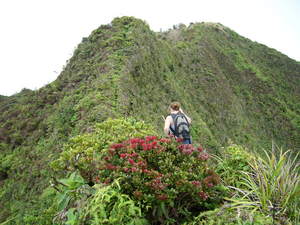
If you attempt Lanipo, be prepared to do some rock hopping in the first mile where the trail drops from its Maunalani Heights starting point into a low saddle and resumes climbing. Thereafter, you’ll be subjected to a long series of mostly ups and a few downs. Along the way, you can look down into both Palolo and upper-Manoa valleys. Near the top, you can look left into upper-Palolo Valley and see Ka’au Crater and a waterfall that cascades from a gap in it. Beautiful stuff, no doubt. There are a couple of nice, relatively flat hilltops with panoramic views along the route that are good places to catch one’s breath. Pitching a tent there for an overnight stay might also be a possibility.
An overnighter was not in my plans on the day I hiked. In fact, I hoped to get to the top much sooner than I did. Here’s a piece of advice for neophyte hikers: 3 1/2 miles (the distance from the trailhead to the summit) traversed on foot on a city street cannot be compared to the same distance on a trail like Lanipo. Plan for at least two to two and a half hours to reach the top.
As I mentioned at the beginning, my summit visit was hampered by cloud cover. Having planned to enjoy the great view while eating my bagel and banana lunch, I was disappointed about the white stuff obscuring my view. Nonetheless, a Ko’olau summit conquest–although not akin to tackling Everest or K2 or Kilimanjaro–is a milestone. And I celebrated it with a fist held heavenward, clouds and whipping tradewinds notwithstanding.
An interesting sidenote about this trail involves veteran Oahu hiker Richard “Dick” Davis, who on Christmas day in 1944 descended to the windward side from Lanipo. Traversing a steep ridge which was near vertical along several stretches, Davis made it down after sunset and after losing all his fingernails, which were ripped off as he clawed his way down the steep pali. Davis’s feat is difficult to appreciate unless one is standing atop Lanipo looking down at distant Windward valley floor. But an amazing if not foolhardy accomplishment it was.
Not nearly as daring, I decided the trail up was the trail down for me. As I tromped makai (oceanward), I was reminded that downhill hiking–because of the repetitive jarring impact–is more painful for my back, legs and feet than uphill hiking. Consequently, I stumbled and limped back down the trail and took about 15 minutes longer to get down the mountain than it had taken me to get up it.
How would I sum up the Lanipo hike? Like Dick Davis, I survived.