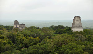
In the early 1900s, the Hensley and Gibson families moved atop Brush Mountain and founded a completely self-sufficient community that at its peak contained over 25 families and is now known as Hensley Settlement. This settlement is one of the key sites to see when hiking The Ridge Trail. While the families have moved on, their legacy remains, and this frontier community featuring many of the original old cabins, barns, buildings, split rail fences, graveyard, and schoolhouse that were made from locally hewn oak and wormy chestnut have been restored. Depending on the time of the year, there is an abundance of wildlife and it is not uncommon to encounter groups of deer loping through the fields as well as to encounter bears along the hike.
There are a variety of ways to gain access to this historic site, and many visitors to Cumberland Gap National Park in nearby Middlesboro, KY often take one of the guided tours of the area. This was one of my children’s favorite places to hike when they were growing up, and it is a hike that is both educational and enjoyable for all ages. While traveling by tour bus is certainly easier, if you enjoy hiking and a bit of a challenge, there are other ways to access the settlement by foot that are quite scenic and peaceful and that will allow you to take in other “secret” areas that are enjoyed mainly by locals and the rare backcountry aficionado. If you plan to camp overnight in the area, you will still need to stop by the visitor’s center to the park to get a permit, and reservations can be made up to three months in advance by calling (606) 248-2817. While strenuous, it is well worth the time, effort and sweat, to see the other amazing natural sites in the area on foot! Depending on how many side trails that you add to your hike, you can easily walk 16 to 21 miles or more on this adventure! I will caution you now, that water and facilities are extremely limited, and you will want to pack for emergencies and bring your own water. At different times of the year there are limited amounts of water at the stream at Martin’s Fork, and at the seasonal waterfall at the Sand Cave, but this needs to be filtered and purified, and while there is a pump at Hensley Settlement, it is often turned off during the colder months.
Rather than taking the tour from the park, when we are going to visit Hensley Settlement, The Sand Cave, White Rocks, Pinnacle Overlook and Martin’s Fork, we prefer to start our journey by beginning our hike in Lee County, VA at the Chadwell Gap Trail. The Cumberland Gap National Park and Visitor’s center can be reached via U.S. 25E from Kentucky and Tennessee, or U.S. 58 from Virginia. The Visitor Center is on U.S. 25E in Middlesboro, Kentucky. To get to the Chadwell Gap Trail, leave the park Visitor center and take 25E through the tunnel. Take U.S. 58 when you cross it. Shortly after passing the Wilderness Road State Park, you will see 690 on your right. This road leads to the parking area described. The parking area and trailhead are off of a driveway, but are clearly marked. The Visitor Center has maps detailing all of this. In recent years this trail has been closed at various times, when it is we then start our hike at the Ewing Gap Trail, in Lee County, VA. This trail is also steep, and is a difficult three mile trip from the Civic Park Parking lot in Ewing before it connects to the Ridge Trail and the White Rocks.
The Chadwell Gap trail is the original trail that members of the Hensley and Gibson families used to walk, single file, on and off of the mountain; it climbs for about 2.1 miles and gains around 2,000 vertical feet before intersecting with the 21 mile long Ridge trail, which runs along the border of the state lines of Virginia and Kentucky. At the far eastern end of the Ridge Trail are the scenic White Rocks and at the Far Western End is the Pinnacle Overlook. In between these two ends are Hensley Settlement, Martin’s Fork and The Sand Cave.
Once you have reached the point where the Chadwell Gap Trail joins with the Ridge Trail, take the left turn and travel another .4 miles to Martin’s Fork. Martin’s Fork is a campground that features a cabin with fireplace and three primitive wooden bunkbeds (bring your own bedding). There are places at the campground for tents with established fire rings and a place to tie up your horses is also available. Rentals of the cabin fill up quickly, especially for weekends, and reservations and a $10 fee plus KY tax are required. If you can make a reservation for this campground, this is really the best place to use as your base when hiking the entire Ridge Trail.
From Martin’s Fork it is another .8 miles to Hensley Settlement on the right, and from Martin’s Fork it is about 3 miles to the Sand Cave and another 1 mile from the Sand Cave to the White Rocks on the left.
The Sand Cave is an astonishing natural feature of the region and cannot be missed on any hiking trip to this area. The Sand Cave is not a real cave but a gigantic rock shelter formed by the erosional forces of wind, water and ice. At the low end of the opening is a waterfall. To reach Sand Cave, you travel downwards through a path that winds its way beneath branches of hemlocks and rhododendron that make a natural “green tunnel” for you to walk through as they grow up along a bubbling crystal clear stream that is strewn with quartzite sandstone pebbles. Once you enter this natural formation that towers hundreds of feet in the air, you cannot help but be dazzled by the more than 21 different colors of the sandstone ceiling that swirl above your head and the 1.5 acres of fine dry sand of multiple shades inside. Pictures of the inside will remind you of the remoteness and tranquility of space and the moon. It’s an additional mile to the White Rocks, which served as a beacon to pioneers and travelers searching for the “Gap” in the mountains so that they could make their way West. While many people take the 4 mile drive up the winding and steep Skyland Road to Pinnacle Overlook, it is possible to hike there from Hensley Settlement. It is an additional 12 mile hike of mostly level to gently rolling trail that winds its way through the trees along the mountain top from Hensley Settlement to the Pinnacle Overlook. Hensley Settlement is actually another 1,000 feet in elevation than the summit at Pinnacle Overlook. From Pinnacle Overlook, you can see all three states of Virginia, Kentucky and Tennessee, and before pollution clouded the skies to the south, it was possible to see 7 states, including Georgia, from the summit. Whether you make the trip to the summit by car or hike, it offers genuinely breaktaking views regardless of the time of year, but the colors of the foliage in the fall and spring are truly stunning and should not be missed.
Hiking the Chadwell Gap Trail and then the adjoining Ridge Trail in the Cumberland Gap National Park is my favorite hike to find peace and serenity. On any given hike at any time of the year, it contains an abundance of wildlife and unique, natural formations that make this an exciting but relaxing trip.
The Ridge Trail is but one of over 85 miles of hiking trails available in the Cumberland Gap National Park. Nearby Wilderness Road State Park offers additional trails such as Indian Ridge Trail and Wilderness Road Trail that are equally interesting and relaxing and also features the historically restored Martin’s Station that offers period reenactments and more for visitors to enjoy.